This work is licensed under a Creative Commons Attribution-ShareAlike 4.0 International License.
Joël Liénard joel.lienard@laposte.net
This work is licensed under a Creative Commons Attribution-ShareAlike 4.0 International License.
See procedure of installation and technical elements at the bottom of page
Col de Pailhères |
The place:Dans les Pyrénées orientales (France). Map and aerial view: Geoportail Display of the panorama:(reduced resolution) Download: |
Col du Miraillet |
The place:Near Areches, in Beaufortain ( France) Map and aerial view: Geoportail Display of the panorama:(reduced resolution) Download: |
Les Busards |
The place:In the South of Grenoble ( France) Map and aerial view: Geoportail Display of the panorama:(reduced resolution) Download: |
Le Mont Clocher |
The place:Above Hauteluce, in Beaufortain ( France) South and northwest exposures Map and aerial view: Geoportail Display of the panorama:(reduced resolution) Download: |
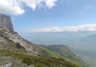
Col de l'Arc |
The place:Near Grenoble (France). In the Vercors. East exposure. Map and aerial view: Geoportail Display of the panorama:(reduced resolution) Download: update nov2012 |
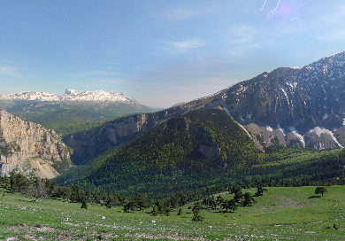
Col des Faïsses |
The place:In the South of Grenoble (France). Under the Obiou. South exposure. Map and aerial view: Geoportail Display of the panorama:(reduced resolution) Download: update nov2012
|
Le Sornin |
The place:Slope dominating Grenoble (France). South exposure. Map and aerial view: Geoportail Display of the panorama:(reduced resolution) Download: update nov2012 |
Alpe de Valbonnais |
The place:Slope situated in the South of Grenoble (France). Exposure West. Map and aerial view: Geoportail Display of the panorama:(reduced resolution) Download:for CRRCSIM 0.9.12, compatible CRRCSIM 0.9.11 update nov2012 |
Brié |
The place:
Slope situated around by Grenoble (France). Northwest exposure. Map and aerial view: Geoportail Display of the panorama:(reduced resolution) Download : |
CRRCSIM version 09.11, preferably 0.9.12 (for "Brié" scenery, rather compiled with option WINDDATA3D=1 and lib CGAL)
download of the simulator
The panorama is a complete panorama (360 ° x 180 °) The assembly of photos (approximately 80) and the calculation of the heights of the terrain were realized by means of several software
The determination of the heights is made by stereoscopy from two panoramas taken at two different heights.
It is be completed by the use of map.
Detailed explanations (only in French)...
CRRCSim uses a generator of updraft according to the relief. This
very rudimentary generator in version 0.9.11 was improved in 0.9.12.
For the slope of Brié, a precalculation of the values of the wind speed
and orientation was made. (http://jugiraud1.free.fr/brie.htm). At
present only in 2D, 3D in project. To use these values, it is necessary
to use CRRCSIM compiled with option WINDDATA3D=1 and library CGAL